Adirondack Fire tower Hike: Champlain Valley's Poke-O-Moonshine
 |
| Poke-O-Moonshine Fire Tower, Keeseville NY |
Elevation: 2,170'
Vertical ascent: 1,450'
Ranger Trail: (red markers) 1.2-mile
Truck Trail: (blue markers) 2.4
We have not climbed Poke-O-Moonshine in quite some time.
My son wants to listen to the song that refers to it by name. My husband and I
look at him in confusion. He quotes the lyrics, “Misty Poke-Moonshine, teardrop
in my eye.”
Hmmm. It leads to a discussion on John Denver, “Country
Roads” and the moonshine, in that song, refers to the home-brew “white
lightening” not an Adirondack hike.
 |
| hiking map of Poke-O-Moonshine Mountain |
 |
| The Red Ranger Trail is a more direct route to the Poke-O-Moonshine summit. |
We can see climbers as we pull in to the old DEC campground. We
watch while two people inch their way from crevice to crack. The kids run out
of the car to scramble up boulders surrounding the abandoned parking area. This
campground has been closed since 2009.
 |
| Beavers cause flooding on part of the Blue Trail. |
 |
| The two trails converge at the remains of the Poke-O-Moonshine fire observer's cabin |
The Truck Trail (blue markers) is longer (2.3-miles) and a more moderate grade.
Though an easier walk, there are some obstacles of its own. Beaver dams block the river cause flooding so we have to scramble over fallen trees to find a shallow place to cross. It is an relatively easy walk to reach the open rocks.
The two trails converge at the old fire observer’s cabin and from there is just .02-miles to the fire tower summit. We stop briefly to explore around the cabin’s foundation and stone chimney. We pass an open ledge before reaching the summit.
A wooden fire tower was first erected in 1912 and later replaced in 1917 with the standardized steel tower standing today. Recently (2017) the fire tower celebrated is centennial.
The Osborne Fire Finder has also been renovated through fundraising. The circular apparatus consists of a brass sighting mechanism that pivots precisely in the center. An arrow corresponds with the compass reading when the sights line up with the point of the fire so the fire tower observer could precisely determine where the fire was located and notify firefighters.
The Friends of Poke-O-Moonshine worked hard since the tower's deactivation in 1988. After years of fundraising, the tower is a safe place that is forever marked in the State and National Registers of Historic Places.
Though an easier walk, there are some obstacles of its own. Beaver dams block the river cause flooding so we have to scramble over fallen trees to find a shallow place to cross. It is an relatively easy walk to reach the open rocks.
 |
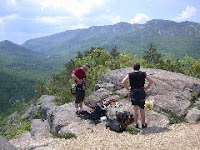
| Open ledges before reaching the summit. |
A wooden fire tower was first erected in 1912 and later replaced in 1917 with the standardized steel tower standing today. Recently (2017) the fire tower celebrated is centennial.
The Osborne Fire Finder has also been renovated through fundraising. The circular apparatus consists of a brass sighting mechanism that pivots precisely in the center. An arrow corresponds with the compass reading when the sights line up with the point of the fire so the fire tower observer could precisely determine where the fire was located and notify firefighters.
 |
| The Osborne Fire Finder used to precisely indicate where smoke or fires were located |
 © Diane Chase is the author of the Adirondack Family Time™ guidebook series. Adirondack Family Time™guidebooks have easy, short Adirondack family hikes for ADK kids, parents, retired, seniors, dog-owners, Adirondack swimming holes, Lake Placid Olympic activities, Adirondack trivia, Adirondack horseback rides, Adirondack snowshoe family trails and more. Look for the Adirondack family guidebooks online or bookstores/museums/sporting good stores. Diane is currently working on the next Adirondack Family Activities™ guide.


Comments