Easy Hikes: Stillwater Mountain Fire Tower (Herkimer County, New York)
 |
| newly renovated Stillwater Mountain Fire Tower |
Distance = 1.0-mile one way
Elevation = 2,244'
Vertical Ascent = 470'
After many years of the Stillwater Mountain Fire tower only being accessible through private lands, the new 1.0-mile trail is now open to the public.
My family has not completed the Adirondack Firetower Challenge, but we do enjoy a beautiful hike to a beautiful view and the Stillwater Mountain Fire Tower fits the bill. We've been told by friends that the trail is finally finished after hours of volunteer work by the Friends of Stillwater Mountain.
We drive through Inlet to get to Eagle Bay, It's always such a beautiful place so the ride is always a delight.
The old trail started near the Observer's Cabin on Stillwater Rd and was marked by pink flagging tape. The new trail has a new parking area, signage with bridge crossings and even a picnic table at the summit.
 |
| Stillwater Mountain new parking area 2016 |
 |
| New bridge on the Stillwater Mountain trail |
The trail is wide and an easy hike. We reach the old logging access road in 0.5-mile. We cross the overgrown road and the trail turns from wooded path to rutted dirt road.
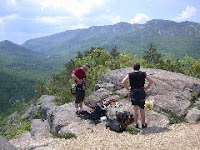
In another 0.5-mile we reach the summit and see the repaired fire tower waiting for us to climb. The final elevation is 2,244' with a vertical ascent of 470'.
 |
| 1919 map table replica of the Stillwater Mountain view |
From the enclosed fire tower cabin we can familiarize ourselves with the view by using the 1919 replica map table. We move the dial and align ourselves with the view.
To get to Stillwater Mountain, take Stillwater Rd for two miles or drive 8-miles from Big Moose Station. The trail is on the northwest side of the road. Enjoy!
 |
| Map of new Stillwater Mountain Fire Tower trail (2016) |
© Diane Chase is the author of the Adirondack Family Time™ guidebook series. Adirondack Family Time™guidebooks have easy, short Adirondack family hikes for ADK kids, parents, retired, seniors, dog-owners, Adirondack swimming holes, Lake Placid Olympic activities, Adirondack trivia, Adirondack horseback rides, Adirondack snowshoe family trails and more. Look for the Adirondack family guidebooks online or bookstores/museums/sporting good stores. Diane is currently working on the next Adirondack Family Activities™ guide.


Comments